
Illustrations: Big River Coalition
BY STAS MARGARONIS
The U.S. Army Corps of Engineers (USACE), New Orleans District began construction of an underwater sill on October 11, 2022, across the bed of the Mississippi River channel to prevent further upriver progression of salt water from the Gulf of Mexico, according to an October 12th news release.[1]
New rainfall impacting the region will relieve the problem but concerns about fresh water and the ship channel to New Orleans and Baton Rouge persist.
USACE says the most immediate threat is to the drinking water of residents of Plaquemines Parish which is South of New Orleans:
“Currently, the greatest risk associated with the saltwater intrusion is the appearance of unsafe salinity levels at the intakes of municipal drinking water intakes in Plaquemines Parish. “[2]
On October 10th the Plaquemines Parish Government warned:
”Plaquemines Parish is issuing a DRINKING WATER ADVISORY effective immediately. The Plaquemines Parish water systems are experiencing higher levels of sodium and chloride from a salt water wedge that is moving up the Mississippi River.”[3]
The declining water level on the Mississippi prompted the Port of Greater Baton Rouge to “reduce the maximum draft recommendation to 41 feet based on low water levels within the Port’s area of responsibility,” according to an advisory by the Big River Coalition.[4]
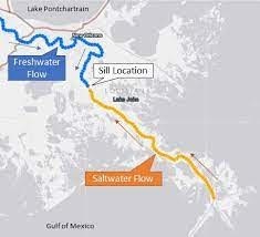
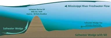
The construction of the underwater sill was necessary because “Mississippi River’s volume of water has fallen to a level that allows salt water to intrude upstream. Saltwater from the Gulf of Mexico moves upriver in a wedge shape that may stretch up approximately 20 miles from the bottom to the surface of the river.”
Illustration: Big River Coalition
To stop the salt water from moving upriver and reduce the risk to freshwater intakes, “the New Orleans District began construction of an underwater barrier sill Oct. 11 at river mile 64, which is near Myrtle Grove, Louisiana, to arrest the progression of saltwater intrusion.”
The sill is being created using sediment dredged from a designated area just upstream for this purpose. Throughout the construction phase, “the Corps will test salinity levels in the river to determine where the saltwater wedge is and how high the sill may need to be built. “[5]
Additionally, the U.S. Coast Guard has issued navigation restrictions around the sill construction site from river mile 63.5 to 64.
In an October 28th advisory, Sean Duffy, executive director, Big River Coalition wrote that he hopes the worst is over:
“The USACE expects to conduct salinity measurements in the vicinity of the constructed salt water wedge over the next 48-hours. The USACE will utilize those salinity measurements to make decisions on the need to build the salt water barrier higher or not. As shared previously there are no draft restrictions in place on the Mississippi River Ship Channel in this area or because of the constructed salt sill elevation.”
In an interview, Duffy’s said a weather system is bringing in much needed rain that will alleviate the low water situation.
Duffy said, in his advisory, that the water level at the key New Orleans Carrollton Gage, had been unusually low but was expected to rise:
“The Carrollton Gage (New Orleans) reading at 0800 hours today (October 28th, 2022) was 1.89 feet with a 24-hour change of – 0.08 feet. The National Oceanic and Atmospheric Administration’s (NOAA) National Weather Service Extended Streamflow Prediction (28-Day) for the Carrollton Gage issued today forecasts stages will continue a slow rise to 4.2 feet and to then begin a slow fall to 3.9 feet on November 25 (2022).[6] The precipitation forecast in the long-range models only account for future precipitation 48-hours in advance, but indications are that the precipitation will help (or is helping) in the battle to halt the salt water wedge from advancing upriver without increasing the height of the salt water sill at least over the next few days.”[7]
As a reference point, Duffy explained, that at the Carrolton Gage:”Mariners are comfortable with the water level at 5 to 8 feet.”
Nevertelss, Duffy is hopeful the worst is over, although he added a note of caution:
“None of us has seen anything like this … The saltwater encroachment is a threat to drinking water as a result of the low water, the Big River Coalition is also reporting and watching changes develop that are most likely related to relative sea level rise and the impacts of climate change, including a number of avulsions below New Orleans that further reduce the flow and self-induced scour that keeping the flow in the mainline channel produces.”
Duffy says the current height of the sill is still allowing the ship channel to New Orleans to operate with a 50-foot draft, “but if the sill has to be built higher, then the ship channel draft will have to change.”
FOOTNOTES
[1] https://www.mvn.usace.army.mil/Media/News-Releases/Article/3185907/corps-begins-constructing-underwater-sill-to-halt-saltwater-intrusion-in-missis/
[2] Ibid.
[3] https://www.plaqueminesparish.com/Search?searchPhrase=salt%20water%20intrusion
[4] Sean Duffy, Big River Coalition, EMERGENCY UPDATE 102822: SALT WATER SILL OPERATIONS
[5] https://www.mvn.usace.army.mil/Media/News-Releases/Article/3185907/corps-begins-constructing-underwater-sill-to-halt-saltwater-intrusion-in-missis/
[6] In 1888, Frederick Haynes Newell. the first full-time appointee to the new Irrigation Survey and later became the first Chief Hydrographer of the U.S. Geological Survey. Newell is purported to be the person responsible for the adoption of the USGS spelling of “gage” instead of “gauge.” Around 1892, Newell reasoned that “gage” was the proper Saxon spelling before the Norman influence added a ‘u’. (Source: https://www.usgs.gov/faqs/why-does-usgs-use-spelling-gage-instead-gauge)
[7] Duffy, Emergency Update October 28, 2022